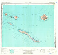
USGS Topo Quad Rat Islands, Alaska
Download Rat Islands
Download Rat Islands
Southern Latitude:
51.2500 N
Eastern Longitude:
180.0000
Northen Latitude:
52.2500 N
Western Longitude:
178.0000
Archipelago(s) in Rat Islands
Rat Islands,
Bar(s) in Rat Islands
Petrel Bank,
Sugarloaf Knob,
Bay(s) in Rat Islands
Amos Cove,
Burr House Cove,
Chapel Cove,
Chitka Cove,
Clam Bay,
Constantine Harbor,
Crater Bay,
Cyril Cove,
Duck Cove,
Duk Cove,
East-northeast Indent,
East-southeast Bight,
Fumarole Cove,
Gunners Cove,
Kirilof Bay,
Landslide Cove,
Makarius Bay,
Midden Cove,
North Bight,
North-northeast Bight,
North-northwest Bight,
Pluton Cove,
Sand Beach Cove,
Sandy Cove,
Signal Cove,
South Bight,
South-southeast Bay,
South-southwest Indent,
Southeastern Cove,
Southwest Indent,
Square Bay,
Stone Beach Cove,
West Cove,
West-northwest Bight,
West-Southwest Bight,
Whale Cove,
William Cove,
Williwaw Cove,
Cape(s) in Rat Islands
Aleut Point,
Andesite Point,
Ayugadak Point,
Banjo Point,
Bird Cape,
Buoy Point,
Chitka Point,
Chugul Point,
Clam Point,
Constantine Point,
Crown Reefer Point,
Double Point,
East Cape,
East Point,
East-southeast Head,
East-southeast Point,
Finger Point,
Grampus Point,
Gray Point,
Gula Point,
Iron Point,
Ivakin Point,
Kirilof Point,
Krysi Point,
Low Bluff,
Midden Point,
North-northwest Head,
Northeast Point,
Northwest Head,
Omega Point,
Patterson Point,
Peregrine Point,
Petrel Point,
Petrel Point,
Pillow Point,
Pochnoi Point,
Pratt Point,
Prokhoda Point,
Rifle Range Point,
Rim Point,
Saint Makarius Point,
Sea Otter Point,
Sitkin Point,
South Point,
South Tuman Point,
South-southeast Point,
South-southeast Point,
South-southwest Point,
South-southwest Point,
Southeast Point,
Tuman Point,
West-northwest Point,
Channel(s) in Rat Islands
Amchitka Pass,
Khvostof Pass,
Krysi Pass,
Little Sitkin Pass,
Oglala Pass,
Rat Island Pass,
Cliff(s) in Rat Islands
C. P. Bluff,
North Head,
Southwest Knob,
Square Bluff,
Sugarloaf Head,
Tuman Head,
Zapad Head,
Hill(s) in Rat Islands
Amchixtam Chaxsxii,
Lakeshore Cone,
Island(s) in Rat Islands
Amchitka Island,
Bat Island,
Bird Rock,
Column Rocks,
Davidof Island,
Hawadax Island,
Khvostof Island,
Little Sitkin Island,
Mex Island,
Pin Rock,
Pyramid Island,
Sea Otter Rock,
Segula Island,
Semisopochnoi Island,
Tanasux,
Windy Island,
Lake(s) in Rat Islands
Emerald Lake,
Fenner Lake,
Hanitxux,
Jones Lake,
Long Lake,
Silver Salmon Lake,
Mountain(s) in Rat Islands
Anvil Peak,
Mount Cerberus,
Ragged Top,
Segula Peak,
Sugarloaf Peak,
Threequarter Cone,
Ridge(s) in Rat Islands
Column Ridge,
Perret Ridge,
Stream(s) in Rat Islands
Bridge Creek,
Falls Creek,
Fenner Creek,
Jones Creek,
Limpet Creek,
Teal Creek,
Ultra Creek,
White Alice Creek,
Valley(s) in Rat Islands
Fumarole Valley,
Village(s) in Rat Islands
Amchitka,
