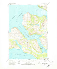
USGS Topo Quad Afognak A-4, Alaska
Download Afognak A-4
Download Afognak A-4
Southern Latitude:
58.0000 N
Eastern Longitude:
-153.0000
Northen Latitude:
58.2500 N
Western Longitude:
-153.3333
Bay(s) in Afognak A-4
Malina Bay,
Malka Bay,
Muskomee Bay,
Onion Bay,
Selief Bay,
Cape(s) in Afognak A-4
Bukti Point,
Cape Nuniliak,
Dolphin Point,
Steep Cape,
Ustia Point,
Channel(s) in Afognak A-4
Raspberry Strait,
Dam(s) in Afognak A-4
Port Wakefield Dam,
Island(s) in Afognak A-4
Raspberry Island,
Lake(s) in Afognak A-4
Lower Malina Lake,
Upper Malina Lake,
Mountain(s) in Afognak A-4
Cloud Peak,
Godfrey Mountain,
Mount Lowell Wakefield,
Pillar(s) in Afognak A-4
Laida Rocks,
Stream(s) in Afognak A-4
Bear Creek,
Malina Creek,
Village(s) in Afognak A-4
Port Wakefield,
