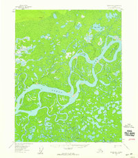
USGS Topo Quad Beaver B-1, Alaska
Download Beaver B-1
Download Beaver B-1
Southern Latitude:
66.2500 N
Eastern Longitude:
-147.0000
Northen Latitude:
66.5000 N
Western Longitude:
-147.5000
Channel(s) in Beaver B-1
New Cutoff,
Flat(s) in Beaver B-1
George Meadow,
Island(s) in Beaver B-1
Joe Devlin Island,
Joe Guay Island,
Lake(s) in Beaver B-1
Annie Lake,
Argo Bill Lake,
Elbow Lake,
George Lake,
Greenhorn Lake,
Island Lake,
Mud Lakes,
Ninemile Lake,
Riley Lake,
Tony Lake,
Twelvemile Lake,
Pass(s) in Beaver B-1
Ed Berg Slough,
Slough(s) in Beaver B-1
Fish Slough,
Jack Uheen Slough,
Stream(s) in Beaver B-1
Fish Creek,
Tony Slough,
Trail(s) in Beaver B-1
Chandalar Trail,
Village(s) in Beaver B-1
Beaver,
