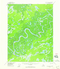
USGS Topo Quad Black River D-6, Alaska
Download Black River D-6
Download Black River D-6
Southern Latitude:
66.7500 N
Eastern Longitude:
-143.5000
Northen Latitude:
67.0000 N
Western Longitude:
-144.0000
Lake(s) in Black River D-6
Belle Lake,
Cabin Lake,
Island Lake,
Loon Lake,
Moosehorn Lake,
Mud Lake,
Rat Lake,
Red Dog Lake,
Rock Lake,
Rock Lake,
Sams Big Lake,
Schrader Lake,
Waterfall Lake,
Willow Lake,
Pass(s) in Black River D-6
Goose Slough,
River(s) in Black River D-6
Middle Channel,
Middle Channel Porcupine River,
Slough(s) in Black River D-6
Joe Ward Slough,
Rock Slough,
Sixmile Slough,
Stream(s) in Black River D-6
Black River Slough,
Chandalar Creek,
Henderson Slough,
