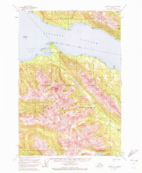
USGS Topo Quad Juneau A-2, Alaska
Download Juneau A-2
Download Juneau A-2
Southern Latitude:
58.0000 N
Eastern Longitude:
-134.3333
Northen Latitude:
58.2500 N
Western Longitude:
-134.6667
Bay(s) in Juneau A-2
Admiralty Cove,
Young Bay,
Beach(s) in Juneau A-2
Ready Bullion Beach,
Young Beach,
Cape(s) in Juneau A-2
Point Hilda,
Inner Point,
Middle Point,
Point Young,
Island(s) in Juneau A-2
Scull Island,
Lake(s) in Juneau A-2
Slide Lake,
Young Lake,
Mountain(s) in Juneau A-2
Mount Bradley,
Eagle Peak,
McDonough Peak,
River(s) in Juneau A-2
King Salmon River,
Stream(s) in Juneau A-2
Admiralty Creek,
Bullion Creek,
Falls Creek,
Hilda Creek,
Stink Creek,
Trail(s) in Juneau A-2
Young Lake Trail,
