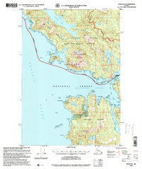
USGS Topo Quad Sitka B-6, Alaska
Download Sitka B-6
Download Sitka B-6
Southern Latitude:
57.2500 N
Eastern Longitude:
-135.6667
Northen Latitude:
57.5000 N
Western Longitude:
-136.0000
Abandoned Towns(s) in Sitka B-6
Cobol,
Area(s) in Sitka B-6
Sealion Rocks,
Bar(s) in Sitka B-6
Brad Rock,
Channel Rocks,
Fortuna Reefs,
Kakul Rock,
Morskoi Rock,
Olga Rock,
Sea Rock,
Vincent Reef,
Bay(s) in Sitka B-6
Bradshaw Cove,
Flat Cove,
Hidden Cove,
Island Cove,
Kalinin Bay,
Louise Cove,
Salisbury Sound,
Salmonberry Cove,
Sea Lion Bay,
Sinitsin Cove,
Sukoi Inlet,
Cape(s) in Sitka B-6
Point Leo,
Point Kruzof,
Point Kakul,
Cape Georgiana,
Fortuna Point,
Hayward Point,
Kalinin Point,
Khaz Peninsula,
Klokachef Point,
Scraggy Point,
Point Slocum,
Sukoi Point,
Twin Point,
Point Vincent,
Channel(s) in Sitka B-6
Fortuna Strait,
Kakul Narrows,
Island(s) in Sitka B-6
Eagle Rock,
Goloi Islands,
Klokachef Island,
Krugloi Islands,
Round Island,
Scraggy Islands,
Sealion Island,
Sealion Islands,
Sinitsin Island,
Lake(s) in Sitka B-6
Lake Leo,
Lake Suloia,
Lake Surprise,
Mountain(s) in Sitka B-6
Mount Georgiana,
Stream(s) in Sitka B-6
Leo Creek,
