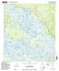
USGS Topo Quad Tanacross A-3, Alaska
Download Tanacross A-3
Download Tanacross A-3
Southern Latitude:
63.0000 N
Eastern Longitude:
-142.0000
Northen Latitude:
63.2500 N
Western Longitude:
-142.5000
Cape(s) in Tanacross A-3
Rock Point,
Lake(s) in Tanacross A-3
Big John Lake,
Big Lake,
Close Lake,
Fish Camp Lake,
Grass Lake,
Joe Lake,
Leaf Lake,
Long Fred Lake,
Long Lake,
Louie Lake,
Midway Lake,
Mundcho Lake,
Nuziamundcho Lake,
Porcupine Grass Lake,
Round Lake,
Swan Lake,
Titus Lakes,
Tlechegn Lake,
Tlocogn Lake,
Tsilchin Lake,
Tutkaimund Lake,
Willow Lake,
Mountain(s) in Tanacross A-3
Big John Hill,
Titus Paul Hill,
River(s) in Tanacross A-3
Kalutna River,
Tetlin River,
Stream(s) in Tanacross A-3
Bitters Creek,
