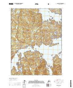
USGS Topo Quad Craig B-2 NE, Alaska
Download Craig B-2 NE
Download Craig B-2 NE
Southern Latitude:
55.3750 N
Eastern Longitude:
-132.3333
Northen Latitude:
55.5000 N
Western Longitude:
-132.5000
Bay(s) in Craig B-2 NE
Goose Bay,
Linney Bay,
Little Goose Bay,
Paul Bight,
Polk Inlet,
Skowl Arm,
Smith Cove,
Smith Lagoon,
Cape(s) in Craig B-2 NE
Khayyam Point,
Thumb Point,
Channel(s) in Craig B-2 NE
Connection Pass,
Island(s) in Craig B-2 NE
East Sentinel Island,
Kasaan Island,
McKenzie Rock,
West Sentinel Island,
Lake(s) in Craig B-2 NE
Ives Lake,
Stream(s) in Craig B-2 NE
Cabin Creek,
Hundred Thousand Creek,
Monument Creek,
Old Franks Creek,
Old Tom Creek,
Virginia Creek,
Village(s) in Craig B-2 NE
Old Kasaan,